Hjemmeside for Anders og Stina
Formentera
1. The Canyons of Cap Barbaria
It is possible to pass from the lighthouse on la Mola to the lighthouse at Cap Barbaria walking along the southern coast of the island, sometimes on the beach and sometimes on the edge of the cliffs. The cliffs are cut by a number of canyons (danish: ådal, Spanish: Torrent) which you have to either cross or go around. This note describes the canyons on the eastern coast of Cap Barbaria. It is build upon my tracks from many tours on foot and bike. It is a history, not intended to be a route description, even it contains a lot of details relevant for exploring.
The major canyons are (from Cap Barbaria Lighthouse) the following:
- Torrent d'en Pins
- Torrent de ses Estanques
- Torrent Fondo
- The Canyon by Racó de s'Ullal
- The Canyon by the cave Cova de sant Valero.
- Torrent de s'Alga
The following maps shows tracks which have brought me along the coast and in contact with the canyons. The tracks exhibit possibilities to access the coast.
The tracks are integrated on a map (Google Maps), where they can be compared to the path from lighthouse to lighthouse, which has been published on Facebook by a user named Fotos de Formentera. This user have published a lot of very fine photos fro all over Formentera.
Also integrated on this map is a path leading to the cave Gran Cova de Sant Valero.
The path is found on a homepage describing the cave.
Overview map
Map containing the six tracks combined with a track Faro a Faro. Additionally a track leading to the cave Gran Cova de Sant Valero
(Extend the map to full screen by clicking the symbol in the upper right corner)
Torrent d'En Pins
Torrent d'Ses Estanques and across Torrent Fondo
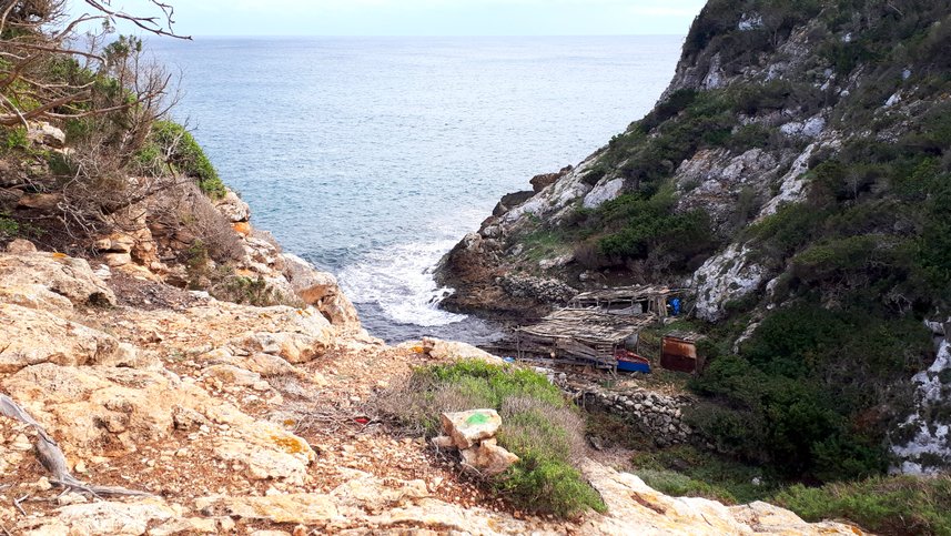
It is no great challenge to find a path down the Torrent Fondo from the northern side. It is more tricky the find the path up on the southern side but it is possible to do it. There is a picture with a path below.
To get over the Torrent de ses Estanques you must follow its upper edge away from the water and then just choose af suitable place to go down the sides, sometimes sliding. It is rather steap, but no rocks only earth and scrub and some trees. The path Faro a Faro takes a little greater detour, probably on an easier visible path.
The track up on the southern side of Torrent Fondo.
Published by the Facebook user Fotos of Formentera as an answer to a question on FB where I mentioned that I had lost the track, which I has found and used in 2019. (I published it as a route in Outdooractive)
From the Philippe Starck Villa to Torrent Fondo
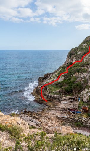
There is a characteristiv red villa, build by Philippe Starck. The part of the route along the cliffs starts at this villa, goes south near the coast. It follows af fine path which also can be used for mountain bike. You passes the villa in an curbe around it, partly marked as private. After a while it folows a wall and then you just continues through the terrain to the Torrent Fondo. If you are lucky you notice some flat stones marked with dots of green paint. You find a not very difficult hair pin path down the valley and at the bottom there are a small number of boathouse with boats. To continue up the opposite side confer with the previous point.
Exploring the areas around Torrent Fondo and Torrent d'Ses Estanques
The following Map (Google) shows some tracks around Torrent Fondo. It also contains a constructed route, made to circumvent the Torrent (Red). The white track is the tour Faro a Faro. You can find out how to pass the Torrent Fondo by combining the different tracks.
If you want to circumvent both the Torrent Fondo and the Torrent de Ses Estanques, the simplest will be to use the white track until it meets the yellow track (Walk with Frida), then follow the yellow track until the point where it is the closest to the red track (the constructed route). The shortcut is not a visible path, but the orange route, another explorative path, shows where it can be found. Where the red track (almost) meets the green track (a track made for exploring the south side path over Fondo Torrent), you take the green track until you are back on the white track. Then continue along the white track.
Punta de Pujolet, next to the cave.
This is a walking path most through scrub and trees and gardens as well. It leads to the cave, but I didn't go for that. You must climb some walls to get to the strech along the sea. May be you can find a way throug the garden without needing to climb the walls.
From the boathouse at Torrent de s'Alga to Punt de Corb Mari.
Easy path on the edge of the cliff. There is a fine way with parking at the little harbour and a short walking path from the Corb to the dirt road leading to the hotel Can Chumberra.
From Kiosko 62 to Torrent de s'Alga
I took this trip bare foot, which was ok. It was very fortunate when I stepped knee deep into a sea of posidonis, when I left the beach to clime the brink. You can see where on the map.
The buttons are links to the trip Faro a Faro, published on Facebook and made available as a route director on Komoot.
Made by the FB-user Fotos of Formentera.